


Texas: Number One for Highway Plans in USA
for Trans Texas Corridor information, see NAFTA Superhighways page
| Trillion Dollar Highway Plans = Multiple Bypass Surgery a state by state list |
|
| High Priority Corridors specified by Congress in 1991, 1995, 1998, 2005, 2012 |
|
| NAFTA Superhighways | |
| Corridors of the Future | |
| J. Edgar Hoover Parkway: transportation surveillance, mileage taxes, RFID & video tolling |
|
| Paving Appalachia:
Corridor A to X in AL, GA, MD, MS, NC, NY, OH, PA, SC, TN, VA, WV |
|
| Alabama | Nebraska |
| Alaska | Nevada |
| Arizona | New Hampshire |
| Arkansas | New Jersey |
| California | New Mexico |
| Colorado | New York |
| Connecticut | North Carolina |
| Delaware | North Dakota |
| Florida | Ohio |
| Georgia | Oklahoma |
| Hawai'i | Oregon |
| Idaho | Pennsylvania |
| Illinois | Rhode Island |
| Indiana | South Carolina |
| Iowa | South Dakota |
| Kansas | Tennessee |
| Kentucky | Texas |
| Louisiana | Utah |
| Maine | Vermont |
| Maryland | Virginia |
| Massachusetts | Washington |
| Michigan | Washington, D.C. |
| Minnesota | West Virginia |
| Mississippi | Wisconsin |
| Missouri | Wyoming |
| Montana | |
High Priority Corridor 3: East - West Transamerica Corridor
I-66, US 460, Kentucky 80, US 400, US 54, I-40
East-West Transamerica Corridor commencing on the Atlantic Coast in the Hampton Roads area going westward across Virginia to the vicinity of Lynchburg, Virginia, continuing west to serve Roanoke and then to a West Virginia corridor centered around Beckley to Welch as part of the Coalfields Expressway described in section 1069(v), then to Williamson sharing a common corridor with the I-73/74 Corridor (referred to in item 12 of the table contained in subsection (f)), then to a Kentucky Corridor centered on the cities of Pikeville, Jenkins, Hazard, London, Somerset; then generally following the Louie B. Nunn Parkway corridor [I-66] from Somerset to Columbia, to I-65; then to Bowling Green, Hopkinsville, Benton, and Paducah, into Illinois, and into Missouri and exiting western Missouri and moving westward across southern Kansas.
In northwest Texas, upgrade Route 54.
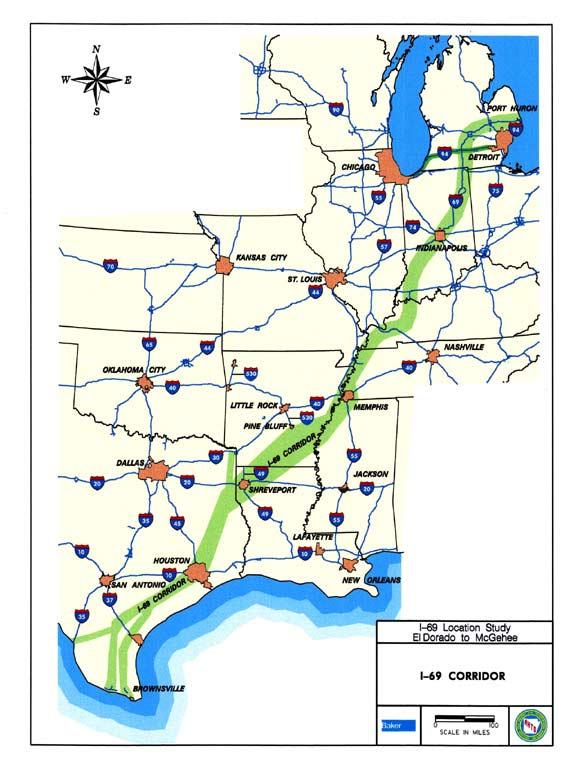
High Priority Corridor 18: NAFTA Superhighway
I-69, I-94, I-530, Routes 59, 77, 281, 82, 61, 51, Purchase Parkway, I-164, Indiana 37
Corridor from Sarnia, Ontario, Canada, through Port Huron, Michigan, southwesterly along Interstate Route 69 through Indianapolis, Indiana, through Evansville, Indiana, Memphis, Tennessee, Mississippi, Arkansas, Shreveport / Bossier Louisiana, to Houston, Texas, and to the Lower Rio Grande Valley at the border between the United States and Mexico, as follows: [I-69]
- In Michigan, the corridor shall be from Sarnia, Ontario, Canada, southwesterly along Interstate Route 94 to the Ambassador Bridge interchange in Detroit, Michigan.
- In Michigan and Illinois, the corridor shall be from Windsor, Ontario, Canada, through Detroit, Michigan, westerly along Interstate Route 94 to Chicago, Illinois.
- In Tennessee, Mississippi, Arkansas, and Louisiana, the Corridor shall--
- follow the alignment generally identified in the Corridor 18 Special Issues Study Final Report; and
- include a connection between the Corridor east of Wilmar, Arkansas, and west of Monticello, Arkansas, to Pine Bluff, Arkansas
- In the Lower Rio Grande Valley, the Corridor shall-
- include United States Route 77 from the Rio Grande River to Interstate Route 37 at Corpus Christi, Texas, and then to Victoria, Texas, via United States Route 77; [I-69 East]
- include United States Route 281 from the Rio Grande River to Interstate Route 37 and then to Victoria, Texas, via United States Route 59; [I-69 Central] and
- include the Corpus Christi North-side Highway and Rail Corridor from the existing intersection of United States Route 77 and Interstate Route 37 to United States Route 181, including FM511 from United States Route 77 to the Port of Brownsville.
- In Kentucky, the corridor shall utilize the existing Purchase Parkway from the Tennessee State line to Interstate 24.
High Priority Corridor 20: Route 59 Corridor (I-69)
United States Route 59 Corridor from Laredo, Texas, through Houston, Texas, to the vicinity of Texarkana, Texas. [I-69]
High Priority Corridor 23: Interstate 35
The Interstate Route 35 Corridor from Laredo, Texas, through Oklahoma City, Oklahoma, to Wichita, Kansas, to Kansas City, Kansas/ Missouri, to Des Moines, Iowa, to Minneapolis, Minnesota, to Duluth, Minnesota, including I-29 between Kansas City and the Canadian border and the connection from Wichita, Kansas, to Sioux City, Iowa, which includes I-135 from Wichita, Kansas to Salina, Kansas, United States Route 81 from Salina, Kansas, to Norfolk, Nebraska, Nebraska State Route 35 from Norfolk, Nebraska, to South Sioux City, Nebraska, and the connection to I-29 in Sioux City, Iowa.
High Priority Corridor 27: Camino Real Corridor
The Camino Real Corridor from El Paso, Texas, to Denver, Colorado, as follows:
- In the State of Texas, the Camino Real Corridor shall generally follow--
- .arterials from the international ports of entry to I-10 in El Paso County; and
- .I-10 from El Paso County to the New Mexico border.
- In the State of New Mexico, the Camino Real Corridor shall generally follow--
- I-10 from the Texas Border to Las Cruces; and
- I-25 from Las Cruces to the Colorado Border.
- In the State of Colorado, the Camino Real Corridor shall generally follow I-25 from the New Mexico border to Denver continuing to the Wyoming border.
- In the State of Wyoming, the Camino Real Corridor shall generally follow--
- I-25 north to join with I-90 at Buffalo; and
- I-90 to the Montana border.
- In the State of Montana, the Camino Real Corridor shall generally follow--
- I-90 to Billings; and
- Montana Route 3, United States Route 12, United States Route 191, United States Route 87, to I-15 at Great Falls; and
- I-15 from Great Falls to the Canadian border.
High Priority Corridor 38: The Ports-to-Plains Corridor
The Ports-Plains Corridor from Laredo, Texas, via I-27 to Denver Colorado, shall include:
- In the State of Texas the Ports-to-Plains Corridor shall generally follow United States Route 287 from Dumas to the border between the States of Texas and Oklahoma, and also United States Route 87 from Dumas to the border between the States of Texas and New Mexico.
- In the State of Oklahoma, the Ports-to-Plains Corridor shall generally follow United States Route 287 from the border between the States of Texas and Oklahoma to the border between the States of Oklahoma and Colorado.
- In the State of Colorado, the Ports-to-Plains Corridor shall generally follow
- ed States Route 287 from the border between the States of Oklahoma and Colorado to Limon; and
- Interstate Route 70 from Limon to Denver
- In the State of New Mexico, the Ports-to-Plains Corridor shall generally follow United States Route 87 from the border between the States of Texas and New Mexico to Raton.
High Priority Corridor 51: SPIRIT Corridor
The SPIRIT Corridor on United States Route 54 from El Paso, Texas, through New Mexico, Texas, and Oklahoma to Wichita, Kansas. [partial overlap with Corridor 3]
High Priority Corridor 55: Interstate 20-635-30-40
In Texas, Interstate Route 20 from Interstate Route 35E in Dallas County, east to the intersection of Interstate Route 635, north to the intersection of Interstate Route 30, northeast through Texarkana to Little Rock, Arkansas, Inter-state Route 40 northeast from Little Rock east to the proposed Interstate Route 69 corridor.
High Priority Corridor 56: La Entrada al Pacifico Corridor
- In the State of Texas, the La Entrada al Pacifico Corridor consisting of the following highways and any portion of a highway in a corridor on 2 miles of either side of the center line of the highway:
- State Route 349 from Lamesa to the point on that highway that is closest to 32 degrees, 7 minutes, north latitude, by 102 degrees, 6 minutes, west longitude.
- The segment or any roadway extending from the point described by subparagraph (A) to the point on Farm-to-Market Road 1788 closest to 32 degrees, 0 minutes, north latitude, by 102 degrees, 16 minutes, west longitude.
- Farm-to-Market Road 1788 from the point described by subparagraph (B) to its intersection with Interstate Route 20.
- Interstate Route 20 from its intersection with Farm-to-Market Road 1788 to its intersection with United States Route 385.
- United States Route 385 from Odessa to Fort Stockton, including those portions that parallel United States Route 67 and Interstate Route 10.
- United States Route 67 from Fort Stockton to Presidio, including those portions that parallel Interstate Route 10 and United States Route 90.
NAFTA Superhighway - I-35 upgrade / I-69 / Trans-Texas Corridor
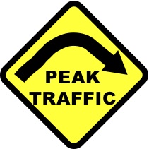
www.peaktraffic.org/nafta.html
The Trans Texas Corridor is a series of planned super highways without parallel (yes, they are bigger in Texas). It would include freeways for cars, truck only lanes, freight and passenger rail lines, and utilities - power lines, water pipes, oil and gas pipelines. It is a prototype of several other "corridors" around the country. After considerable controversy, these plans were scaled back but the new highways are still being piecemealed into place.
www.truthbetolled.com
movie about the Trans Texas Corridor superhighways (in opposition)http://dfazack.typepad.com/truth_be_tolled/
blog for "Truth Be Tolled"http://corridornews.blogspot.com
The Trans-Texas Corridors, eminent domain abuse, and the Texas Toll Road Rebellionhttp://transtexascorridor.blogspot.com
www.keeptexasmoving.com (pro-TTC)
Houston
Grand Parkway - Outer Outer Beltway
http://mypeoplepc.com/members/chrisodonnell/unitedtosaveourspring/id89.html
Houston is working the fourth loop highway, 184 miles long and more than $5 billion. The proposed I-69 interstate (the "NAFTA Superhighway") would go through and around the greater Houston area.
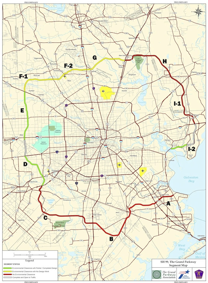
green: environmental clearance with partial / completed design
yellow: environmental clearance with no design work
red: no environmental clearance
grey: completed, open to traffic
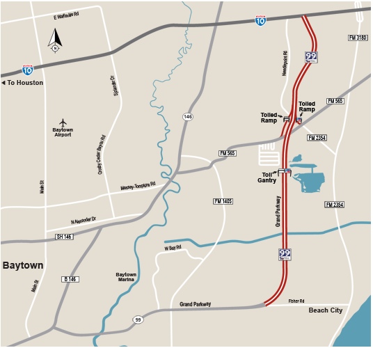
www.texastollways.com/statehighway99/
from: Smart Choices, Less Traffic: The 50 Best and Worst Transportation Projects In the United States,
Sierra Club Beyond Oil Campaign, November 2012
http://content.sierraclub.org/beyondoil/content/smart-choices-less-traffic
Located in Houston, TX, the Grand Parkway is a highway beltway proposed almost 50 years ago, when the price of a gallon of gas was $0.31. Serving as a third beltway around Houston, the Parkway will encourage additional sprawl. Broken into eleven different stages, only 2 segments have been completed, totaling 25 of the planned 185 miles. Construction of a third 15.2-mile, $462 million section, called 'Segment E', began in summer 2011 and is expected to open in 2013. However, even the Grand Parkway Association admits there isn't a traffic-based need for the Segment E; it's about sprawl and development. Segment E crosses through the middle of the Katy Prairie Wetland Habitat, a rest point for migrating waterfowl. The Parkway proposal and associated secondary development poses a flooding threat due to the paving over of this permeable prairie soil, which retains rainfall and reduces runoff downstream. The most immediate downstream collection site for runoff in this area is behind the Addicks Dam, which is one of only six dams rated by the US Army Corps of Engineers at the highest risk level for dam safety. Consequently, the Sierra Club has appealed to the Army Corps of Engineers to deny the permit needed to fill in wetlands. Recently, US District Court issued a ruling in the case of Sierra Club v. US Army Corps of Engineers, which was filed on the basis that the Corps had not properly considered the cumulative impacts on runoff and dam safety arising from Segment E construction. The court found that the Corps had not property considered the cumulative impacts and remanded the Environmental Assessment to the Corps for revision. However, the court did not issue an injunction to halt work on Segment E.
Austin
130 Tollroad recently built - could be part of future NAFTA Superhighway paralleling I-35, part of the (canceled?) Trans Texas Corridor proposal. Route 130 has an 85 mph (136 kilometers per hour) speed limit, the highest in the United States, ensuring that motorists can even more rapidly use finite fossil fuels.
anti-130 site: http://bicycleaustin.info/roadways/sh130/index.html

Texas State Highway 45 Southwest Austin
from: Smart Choices, Less Traffic: The 50 Best and Worst Transportation Projects In the United States,
Sierra Club Beyond Oil Campaign, November 2012
http://content.sierraclub.org/beyondoil/content/smart-choices-less-traffic
Texas State Highway 45 SW is a remnant of an Outer Loop beltway highway around Austin that TxDOT proposed in the 1980s when gas prices were around $1.24/gal. A large portion of the southwest quadrant of the loop was long ago deleted due to lack of need and the environmental sensitivity of the area. Since the 1980s, more than ten thousand acres of land in the area, one of central Texas' most sensitive environmental areas, have been preserved from development, further reducing the demand for such a road. However, this 3.5-mile toll road project is routed through this sensitive area: the Barton Springs portion of the Edwards Aquifer serves 60,000 people as a primary source of drinking water, and gives rise to a number of springs including the famous Barton Springs, the water source for Austin's iconic natural urban swimming pool. The porous limestone aquifer is recharged as rainwater flows into fissures in creek beds and into open natural land. The road threatens the endangered Barton Springs salamander, passes through endangered Golden- cheeked warbler habitat, and passes directly over at least one cave known to harbor extremely rare cave-dwelling invertebrates. Texas Department of Transportation consultants have mapped significant recharge features for the aquifer in the 3.5 mile right of way of the toll road. Impervious cover and road and traffic runoff would seriously threaten the quality and quantity of water from this key aquifer.
Dallas
Several new tollroads have been built in north Dallas to serve the suburban sprawl (aka "white flight"). One of these new highways is the President George Bush Turnpike (named after Bush the First).
Trinity Parkway - new billion dollar highway planned through downtown in Trinity River floodplain (new light rail system also recently built with additions under construction)
www.ntta.org/roadsprojects/futproj/trihwy/Pages/default.aspx
North Texas Tollway Authority
www.texaswatchdog.org/2009/02/stuck-in-park-dallas-trinity-parkway-has-a-budget-deficit-of-a-billion-dollars-seriously/
Stuck in Park: Dallas' Trinity Parkway has a budget deficit of a billion dollars. Seriously.
Friday, Feb 06, 2009
By Matt Pulle
It's exceedingly rare in politics for one side in a campaign to be proven right so quickly, but that's what's happened in Dallas' Trinity River debate.
In November 2007, voters here chose to construct a $1.8 billion toll road on top of the levees as part of the city's decade-long Trinity River Project. And now, a year and a half later, I think a lot of those voters wouldn't mind a do-over.
Throughout the campaign, opponents of the highway—a scattered coalition of fiscal conservatives, young progressives and East Dallas neighborhood types--brought up two main points: One, there wasn't nearly enough funding to build the road. Two, it would be impossible, if not dangerous, to build a toll road in a floodplain with downtown Dallas in the path of that flood.
Today, the Dallas Morning News, which endorsed the plan to build the highway, reported that "the Trinity Parkway could cost close to $1 billion more than the North Texas Tollway Authority can afford to pay to build it." That's because the toll road will simply not generate enough in user fees to pay for its construction.
http://rightbrain-leftbrain.blogspot.com/2007/05/dallas-trinity-parkway-once-more-its.html
Dallas Trinity Parkway: Once More, It's All Business
In 1998, the citizens of Dallas voted for Propostion 11, which was to set aside $246 million to turn the Trinity River into a recreational area. Above is the illustration used in the official city brochure. Keep that image firmly in mind. There was no mention in the wording on the ballot of "toll" or "road", nothing about high-speed roadways with no exits into the park, and taking up 1/3 of the park space. But, typical, to Dallas and its usual suspect business interests, the park project got hijacked along the way, unbeknown to the voters, and now includes such a toll road, which has been engineered and re-engineered for the last 8 years, the cost estimate having risen to more than $1 billion. Add to that the the North Texas Tollway Authority, who will own the road (AND will be gifted the land by the City of Dallas), has asked to be exempted from the post-Katrina flood plain engineering requirements. Let me also mention, that Dallas would be the ONLY city in the United States with a highway in a levee.
from: Smart Choices, Less Traffic: The 50 Best and Worst Transportation Projects In the United States,
Sierra Club Beyond Oil Campaign, November 2012
http://content.sierraclub.org/beyondoil/content/smart-choices-less-traffic
First proposed in 1998, the Trinity River Parkway is a proposed 10-mile, 6-lane, controlled access toll road intended to relieve congestion on I-30 and I-35. Currently, the parkway is estimated to cost between $1.4 and $1.8 billion. This means, at up to $222 million per mile, the Trinity River Parkway will have one of the highest costs per mile in the country. In a city with over 40 lanes of freeway surrounding its downtown, another 6 lanes will make no difference in solving the congestion problem. The parkway adds an eighth highway to downtown Dallas, a metro area that is already a non-attainment zone for ozone levels. Furthermore, the route is in the floodway of the notoriously polluted Trinity River and premier recreational urban park. A busy, noisy parkway would ruin the ambient atmosphere that large parks are supposed to generate and provide to the public. The North Texas Tollway Authority is currently in the process of working on an EIS for this roadway.
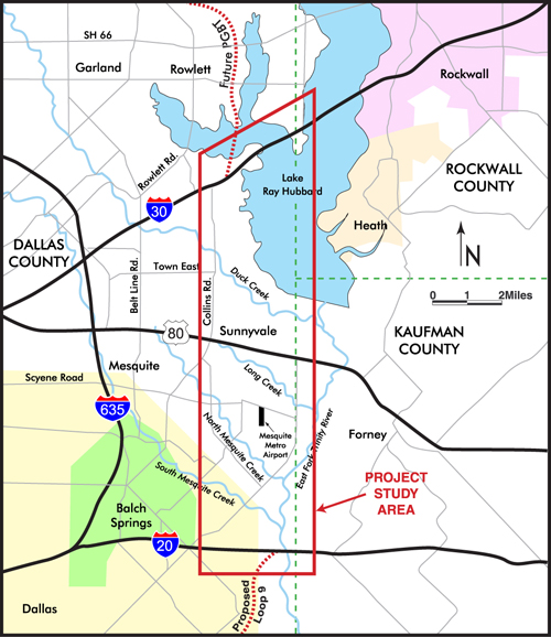
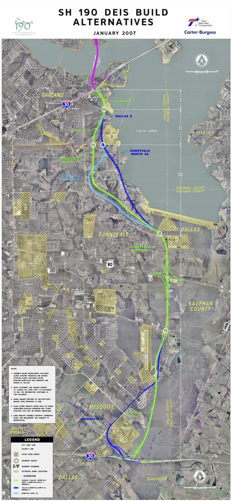
State Highway 190 (eastern segment of Dallas Outer Beltway)
www.theeastbranch.org - ("news" on the project website has not been updated since 2007)
Project Overview
The study corridor for the SH 190 Transportation Study is from Interstate Highway 30 south to Interstate Highway 20 and is approximately 11 miles long. The potential route(s) under study will directly involve the cities of Garland and Mesquite, Town of Sunnyvale, and Dallas County. The map below shows the project study area.
Project Background
An outer loop around Dallas County was first envisioned in 1964. In 1968, the Texas Highway Commission authorized an outer loop around Dallas and designated it as Loop 9. In 1976, a management audit of the State Department of Highway Public Transportation (SDHPT, now TxDOT) indicated a financial shortfall for highway improvements. In 1988, the cities of Garland, Rowlett, Mesquite, and Dallas County sponsored a study to extend SH 190 from SH 78 to IH 20. In 1991, SDHPT commissioned further study of SH 190 from SH 78 to IH 20 and recommended an alignment. In 2000, the North Texas Tollway Authority (NTTA) began an updated/more detailed study to develop the section from SH 78 to IH 30 as a tollway.
Dallas North Tollway extension
www.ntta.org/roadsprojects/futproj/dntphase45/Pages/default.aspx
Initial planning is under way for a proposed 17.6-mile extension of the Dallas North Tollway northward from U.S. 380 to the Collin/Grayson county line (Phase 4A) and from Collin/Grayson county to Farm to Market 121 (Phase 5B). The extension will be a limited access toll road with six main lanes and four frontage road lanes. A scope of work is currently under development, which includes corridor analysis, initial toll feasibility and environmental analysis.
The NTTA Board of Directors chose an alignment for the Phase 4B/5A extension that straddles the Collin-Denton county line and extends 11.9 miles from FM 423 in Collin County to FM 121 in Grayson County.
State Highway 360 extension
www.ntta.org/roadsprojects/futproj/sthwy360/Pages/default.aspx
The Texas Department of Transportation initiated the State Highway 360 corridor study, conducted preliminary studies, processed environmental reviews, obtained environmental clearance and right of way to U.S. 287, and built the existing roadway. The NTTA is now conducting further studies of the corridor. This project is subject to primacy requirements pursuant to Senate Bill 19, passed by the 82nd Texas Legislature.
Project partnering meetings are ongoing to advance the project. Section 1 is expected to result in a 9.7-mile extension of the SH 360 main lanes from Sublett Road/Camp Wisdom Road in southern Tarrant County to U.S. 287 in northwestern Ellis County and northeastern Johnson County.
Two other sections, totaling approximately 11 miles from U.S. 287 to FM 2258 in northeastern Johnson County, are not currently under study.
Extension of State Highway 360 as toll road through southern Tarrant wins preliminary OK
The North Texas Tollway Authority has reached a preliminary agreement with the Texas Department of Transportation to proceed with a tolled extension of State Highway 360.
State Highway 170
www.ntta.org/roadsprojects/futproj/sthwy170/Pages/default.aspx
The Texas Department of Transportation initiated the State Highway 170 corridor study, conducted preliminary studies, processed environmental reviews, obtained environmental clearance and right of way, and built the existing roadway. The NTTA is now conducting further studies of the corridor. The project may go through a market valuation process, a joint NTTA-TxDOT effort, as outlined in Senate Bill 792, passed by the 80th Texas Legislature. Project partnering meetings are ongoing to advance the project, which could result in a 5.8-mile toll road in southwest Denton and northern Tarrant counties. Another section in western Tarrant and Parker county is not currently under study.
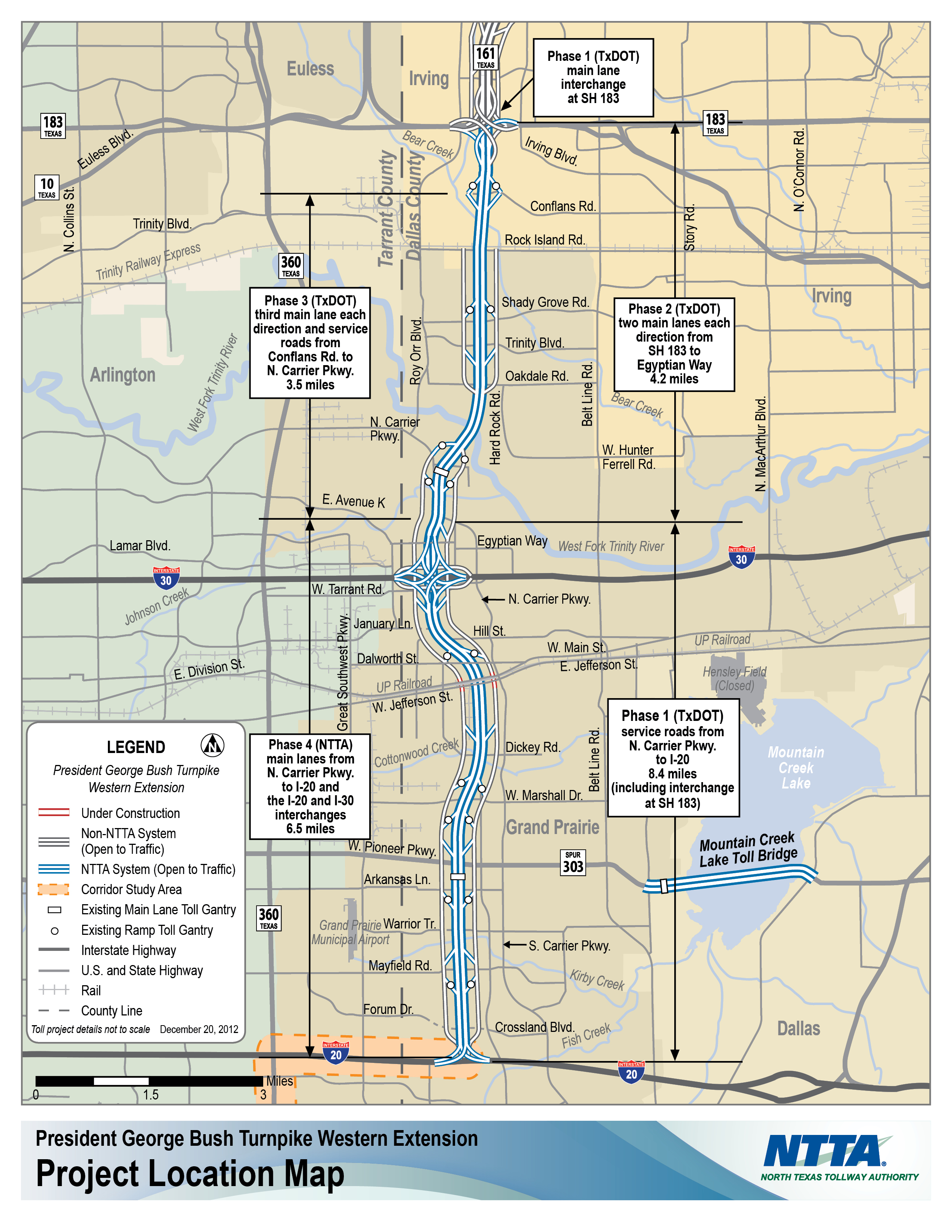
President George Bush Turnpike - Western Extension
www.ntta.org/roadsprojects/projprog/pgbtwestext/Pages/default.aspx
The Bush Turnpike Western Extension provides an 11.5-mile link in the growing loop around Dallas. The corridor consists of the tolled main lanes, known as the Western Extension, and the frontage roads, which are referenced as State Highway 161. The new corridor features cashless tolling on the main lanes in each direction between just north of I-30 south to I-20.
NTTA estimated cost for Phases 2, 3 and 4: $534.6 million (excluding the cost of future expansions).
Chisholm Trail Parkway tollroad
www.ntta.org/roadsprojects/projprog/ChisholmTrail/Pages/default.aspx
The Chisholm Trail Parkway is a 27.6-mile toll road that will extend from downtown Fort Worth south to Cleburne. More than 40 years in the making, the project is a collaboration between the North Texas Tollway Authority, Texas Department of Transportation, the North Central Texas Council of Governments (NCTCOG), Tarrant and Johnson counties, along with the cities of Fort Worth, Burleson and Cleburne, and Western Railroad and Union Pacific Railroad. It is expected to open to traffic in 2014.

San Antonio
Brackenridge Park. A proposed highway through this park was a primary impetus for passage of Section 4(f) of the 1966 Transportation Act, which prohibits Federal aid transportation projects through parks.
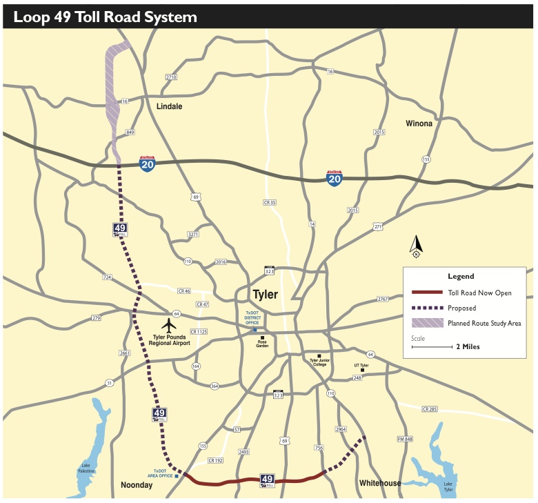
Tyler, Texas - Loop 49 Tollroad
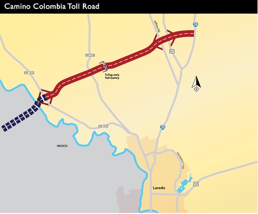
Camino Columbia - Laredo Bypass - connects with Mexico
pro-highway expansion resources:
www.texashighwayman.com
www.texasfreeway.com