


Portland, Oregon
2019: half billion dollar I-5 widening planned (I-84 to I-405)
The No More Freeways coalition is trying to stop a highway expansion in downtown Portland out of concerns for air pollution, climate change, a desire to fund public transit instead and induced traffic (building more lanes in the past usually increased traffic, but that was before Peak and the fracking bubble).
The coalition advocates congestion pricing, which is an electronic tolling system that charges motorists to use the highways. Most of these systems have higher prices during rush hours, with the ostensible goal of encouraging people to stagger their use of the roads or change their behavior to use public transit instead. Laudable in many ways, but it also has more impact on lower income people less able to afford the surcharge. Wealthier drivers will merely grumble and drive on anyway.
In addition, the projected revenue from congestion pricing makes the construction cost seem more affordable to highway planners and politicians. A major factor in whether road expansions get built or not is the financial projections for transportation funding.
Electronic tolling is a surveillance system that monitors all highway traffic in real time.
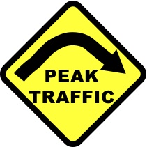
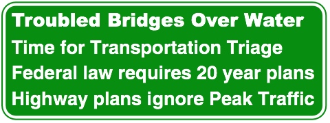
Perhaps No More Freeways will include concerns about Peak Traffic and Peaked Oil as reasons not to expand roads. PeakTraffic.org's legal strategy to prevent oversized highways is focused on the contradictions between Federal law that requires planning for traffic two decades in the future and the reality of energy limits that have disrupted endless growth of traffic congestion.
Dec 2nd Update: We need your help! ODOT is attempting to move forward with the Rose Quarter Freeway Expansion without conducting the Full Environmental Impact Statement (EIS) despite all of our efforts this past spring to hold this agency accountable. (or on the button above) to take action and help us demand that ODOT more rigorously study the climate, traffic, air pollution and traffic safety implications of this dangerous $500 million freeway expansion.
The Oregon Department of Transportation is proposing a $500 million, 1.8 lane-mile expansion of Interstate 5 through the Rose Quarter between the Fremont Bridge (I-405) and the Banfield Freeway (I-84). This exorbitantly costly freeway expansion proposal would be funded through money set aside in HB 2017, the statewide transportation package that passed through Oregon's legislature in June of 2017.
Robert Moses: Portland highways planned
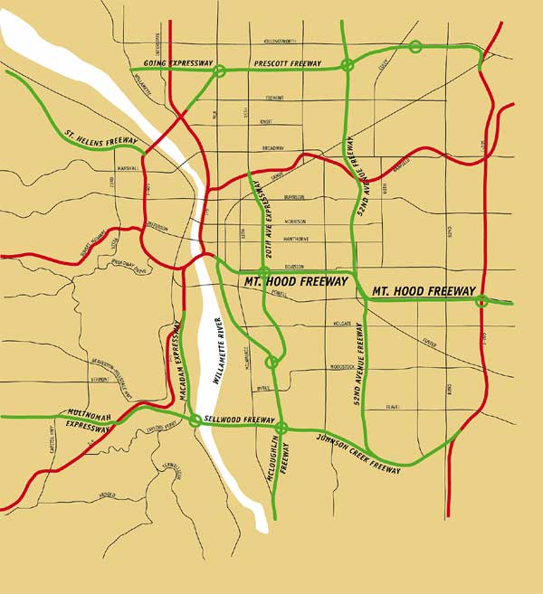 This map from the Portland Planning Division's 1966 development plan illustrates
Robert Moses' vision for a city girdled by freeways.
This map from the Portland Planning Division's 1966 development plan illustrates
Robert Moses' vision for a city girdled by freeways.
Red indicates existing freeways; green lines show freeways that were not built.
(Moses was the chief highway promoter for the New York City region. Robert Caro's book The Power Broker is an exhaustive biography of his legacy.)
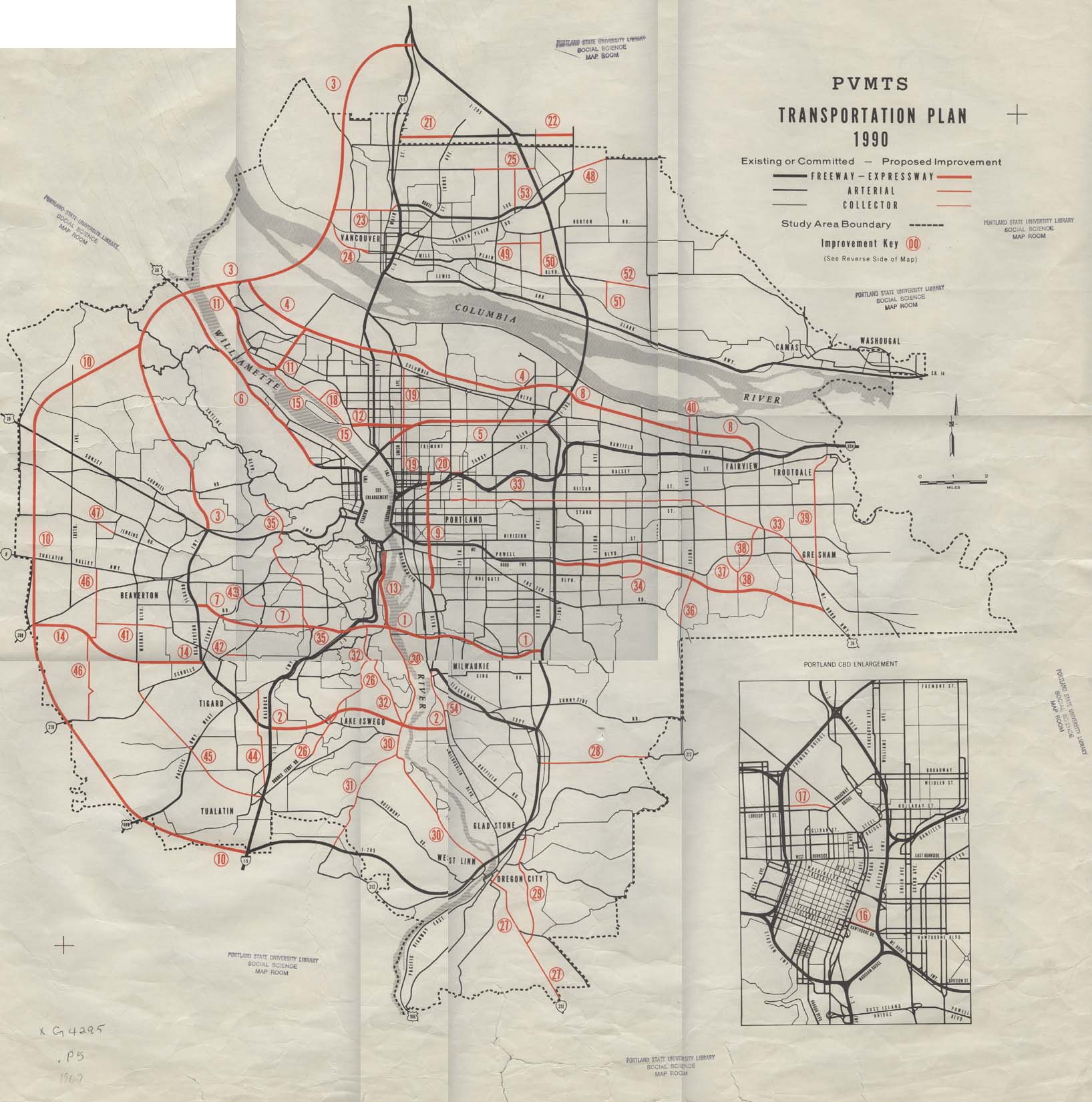
1969 Portland transportation plan (for completion by 1990)
copied from
http://bickenland.lonaf.com/Maps/PVMATS.htm - which has descriptions of each of these proposed highways, built, unbuilt and partly built.
Portland's Dead Highways: Mt. Hood Freeway
Mt. Hood Parkway was a proposed connection between I-84 and US 26. The Sunrise Freeway is a proposed expressway from Clackamas (I-205) to Boring (US 26) outside the Portland UGB (it is still being pushed as a core part of the recent UGB expansion around Damascus). The Western Bypass would have run from I-5 south of I-205 to the Columbia River, where it would have connected to I-5 north of Vancouver, WA. These roads would have been parts of a de facto Portland Outer Beltway.
"Oregon's rapid population and economic growth between 1985 and 2000 led to proposals for new freeways to meet traffic demands and reduce congestion. Proposed projects included the Mount Hood Parkway, the Sunrise Corridor and the Western Bypass in the Portland area and the West Eugene Parkway in Eugene. For a variety of reasons including funding constraints, environmental concerns and citizen opposition, none of the projects was constructed."
– Atlas of Oregon, p. 104 (2001)Myth: Oregon's planning laws hinder development of highways and other large public facilities.
Reality: From 1979 to 1988, Oregon's Highway Division successfully completed 146 major transportation projects. Since Oregon's planning program began (in 1973), only two large project proposals have failed: the Mt. Hood Freeway (east of Portland) and the Roosevelt Freeway (in Eugene). A 1988 study by a multi-agency committee found "the overall record of siting public facilities in Oregon to be good – probably much better than that found in other states.”
www.uoregon.edu/~pppm/landuse/myths.html
Department of Land Conservation and Development DLCD, 1992
http://lcog.org/meetings/mpc/022006/MPC4.g.1.ii_Oregon_Interstate_Background.pdf
Interstate 50th Anniversary
The Story of Oregon’s Interstates
As might be expected, opposition to the re-routing of I-80N developed in the affected neighborhoods. In 1972, a complaint was filed in U.S. District Court seeking to halt the project pending additional corridor studies and filing of an Environmental Impact Statement. Following a similar pattern to that of the other proposed interstate projects during this period, opposition to the Mt. Hood Freeway continued on a variety of fronts, complicated by the then severe energy crisis that created acute gasoline shortages nationwide and pointed out the reliance of the U.S. transportation system on foreign oil supplies. On July 25, 1974, the Portland City Council withdrew its prior approval of the project by a vote of 4 to 1. A year later, in July 1975, the Mt. Hood Freeway was formally withdrawn and the funds reallocated. ...
Some of the funds that had been set aside for I-305 went toward widening a bridge across the Willamette River and toward the completion of the Salem Parkway, which joins I-5 at Keizer and connects to downtown Salem, following much of the route originally identified for I-305. The Salem Parkway was completed in 1986. ...
in early 1979, Governor Atiyeh petitioned the Federal Highway Administration for withdrawal of the I-505 Industrial Freeway from the system and the allocation of those funds for other transportation related projects in the area. In addition to funding traffic improvements in Northwest Portland, the Industrial Freeway withdrawal provided $15 million in funding for the Banfield Transitway Project, $7.4 million for the ODOT fund, and $21 million for improvements on SE 19th Avenue, SE Powell Boulevard, Oregon 217, the Sunset Highway, and Oregon 212. Other projects benefiting from this withdrawal included the Hollywood Business District, Holgate Bridge, the Willamette Greenway, and streetlight and transportation improvements for Swan Island and Columbia Boulevard (Oregon Journal, 15 December 1979).
1978 map: planned Mount Hood Parkway (100% canceled)
THE INTERSTATE HIGHWAY SYSTEM IN OREGON A HISTORIC OVERVIEW
Prepared for the Oregon Department of Transportation Salem, Oregon
Prepared by George Kramer, M.S., HP Senior Preservation Specialist Heritage Research Associates, Inc. Eugene, Oregon
May 2004
Good summary of highway expansion in Oregon. The sections about freeway fights in Portland seems accurate although it claims there were not similar efforts to stop roads in Eugene. Perhaps ODOT has lost the records and institutional memory about the 1960s efforts that kept I-105 from slicing through south Eugene.
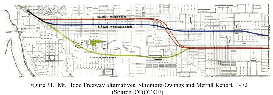
This map of Mt. Hood Freeway alternatives is from this ODOT report.
www.portlandtribune.com/archview.cgi?id=30283
Thank you, neighborhood activists
People can drive past on Division or Clinton streets every day and never know it’s there. Indeed, it wouldn’t be there at all, if supporters of the Mount Hood Freeway had had their way.
The diminutive Piccolo Park (Southeast 28th Avenue between Division and Clinton streets, 503-823-7529) cuts a grassy swath through a residential block. The land was acquired by the state in the 1970s for a freeway, which would have roared through this historic neighborhood, but the freeway planning faltered and in 1989 the parcel was turned into a charming city park.
Piccolo means "small” in Italian, and Piccolo is a kid-size park, with plenty of slides, swings, bridges and other things to climb on and race around.
— AMD
www.wweek.com/story.php?story=6110
30TH ANNIVERSARY ISSUE
HIGHWAY TO HELL
3/9/2005
Nothing shaped Portland so much as the murder of the Mount Hood Freeway.
www.kurumi.com/roads/3di/i505.html
I-505 (cancelled) Oregon
Unbuilt 1.44-mile Portland spur [1]; I-505 would have followed US 30 (Yeon Ave).
northwest out of Portland. Plans for this freeway were withdrawn in the late
1970s, culminating with an approval by President Jimmy Carter to cancel it on
Dec. 14, 1979. [11]
The money was used for other construction projects in the Portland area,
including an alternate design for I-505. (The source doesn't elaborate
on this.) [11]
Part of the proposed route appears on a 1979 Gousha Portland city map. I-505
would have ended at I-405 at the Exit 3 ramps.
A 1970 proposal estimated the road at 0.7 miles and $3 million. [8] A 1972 report
has this summary:
The statement concerns the proposed construction of an urban freeway (Interstate 505) extending from a junction with Interstate 405 westerly to a junction with St. Helens Road (US 30) in Northwest Portland, Multnomah County, Oregon.
The adverse environmental impacts include a general increase in land values in Northwest Portland, the relocation of individuals and commercial/industrial entities, changes in location and degree of noise levels, increased traffic density within the freeway corridor.
1. Route Log and Finder List - Interstate Highways, USDOT, 1978
2. Route Log and Finder List - Interstate Highways, FHWA, Oct. 31, 2002.
7. Summers, Stephen. "Interstate system route numbering." http://www.nwindianahwys.homestead.com/INTER_MAIN.HTML.
(29 May 2003)
8. Congressional Hearings, Federal Aid Highway Act of 1970.
11. Oregon Department of Transportation. "A chronological history of ODOT:
1899 to 1993." http://www.odot.state.or.us/ssbpublic/bss/rmds/history/~chron.htm
(12 March 2004)