


Indiana
| Trillion Dollar Highway Plans = Multiple Bypass Surgery a state by state list |
|
| High Priority Corridors specified by Congress in 1991, 1995, 1998, 2005, 2012 |
|
| NAFTA Superhighways | |
| Corridors of the Future | |
| J. Edgar Hoover Parkway: transportation surveillance, mileage taxes, RFID & video tolling |
|
| Paving Appalachia:
Corridor A to X in AL, GA, MD, MS, NC, NY, OH, PA, SC, TN, VA, WV |
|
| Alabama | Nebraska |
| Alaska | Nevada |
| Arizona | New Hampshire |
| Arkansas | New Jersey |
| California | New Mexico |
| Colorado | New York |
| Connecticut | North Carolina |
| Delaware | North Dakota |
| Florida | Ohio |
| Georgia | Oklahoma |
| Hawai'i | Oregon |
| Idaho | Pennsylvania |
| Illinois | Rhode Island |
| Indiana | South Carolina |
| Iowa | South Dakota |
| Kansas | Tennessee |
| Kentucky | Texas |
| Louisiana | Utah |
| Maine | Vermont |
| Maryland | Virginia |
| Massachusetts | Washington |
| Michigan | Washington, D.C. |
| Minnesota | West Virginia |
| Mississippi | Wisconsin |
| Missouri | Wyoming |
| Montana | |
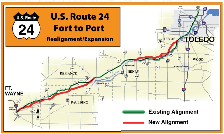
High Priority Corridor 4: Hoosier Heartland Industrial Corridor
Expressway upgrade of Routes 24 and 25 from Lafayette, IN to Toledo, OH. The Fort Wayne to Toledo segment was built to interstate highway design but is not planned to get an Interstate number.
official site: www.in.gov/indot/projects/2405.htm
www.in.gov/indot/projects/2415.htm
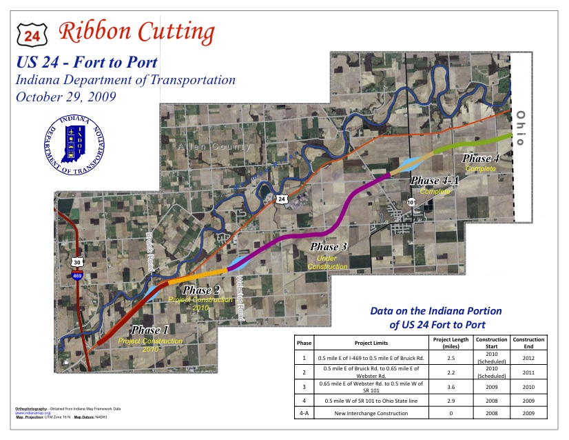
Below are key highlights of the U.S. 24 Fort to Port project and project schedule:
- The Fort to Port project in Indiana was divided into five phases (Phases 1, 2, 3, 4, and 4A).
- The first segment constructed (Phase 4)consisted of two contracts:
- Construction of a new, four-lane highway from the Ohio line to a half mile east of Indiana SR 101. Construction began in May 2008 and completed in October 2009 (Phase 4).
- Construction of an interchange at Indiana SR 101 and new US 24 which began in October 2008 and was completed in October 2009 (Phase 4A).
- The second segment (Phase 3), from a half mile east of Webster Road to a half mile west of Indiana SR 101, began in May of 2009 and was completed in fall 2010.
- The final segments, from east of Bruick Road to east of Webster Road (Phase 2), and from east of I-469 to east of Bruick Road (Phase 1), were placed out for contract bid in February and August of 2010, respectively, were successfully bid and awarded, and will be complete by December 2012.
- Indiana spent to date approximately $110 million on its portion of the U.S. 24 Fort to Port projects (including construction, development costs and right of way).
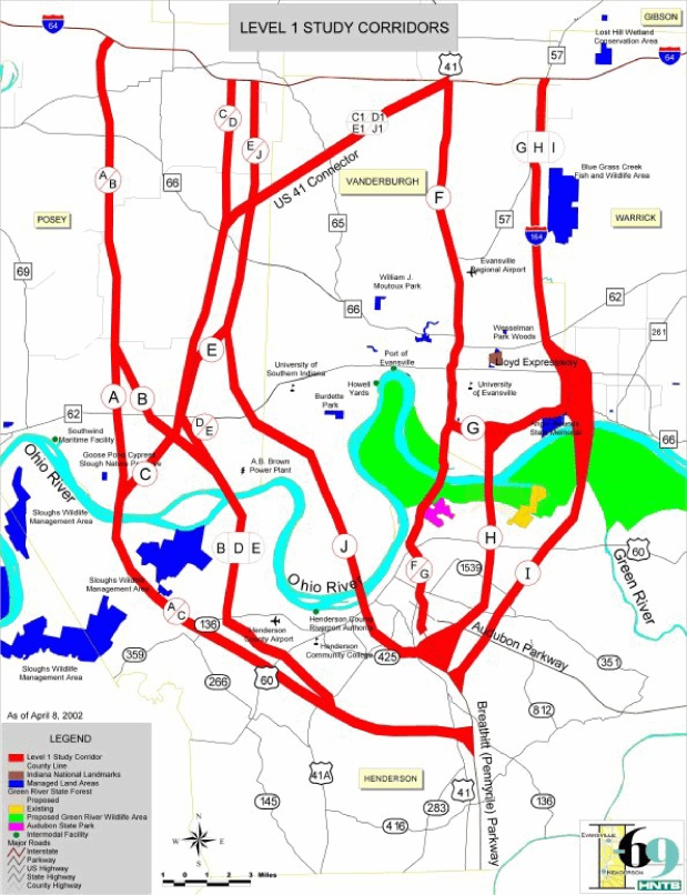
High Priority Corridor 18: NAFTA Superhighway
I-69, I-94, I-530, Routes 59, 77, 281, 82, 61, 51, Purchase Parkway, I-164, Indiana 37
Corridor from Sarnia, Ontario, Canada, through Port Huron, Michigan, southwesterly along Interstate Route 69 through Indianapolis, Indiana, through Evansville, Indiana, Memphis, Tennessee, Mississippi, Arkansas, Shreveport / Bossier Louisiana, to Houston, Texas, and to the Lower Rio Grande Valley at the border between the United States and Mexico, as follows: [I-69]
- In Michigan, the corridor shall be from Sarnia, Ontario, Canada, southwesterly along Interstate Route 94 to the Ambassador Bridge interchange in Detroit, Michigan.
- In Michigan and Illinois, the corridor shall be from Windsor, Ontario, Canada, through Detroit, Michigan, westerly along Interstate Route 94 to Chicago, Illinois.
- In Tennessee, Mississippi, Arkansas, and Louisiana, the Corridor shall--
- follow the alignment generally identified in the Corridor 18 Special Issues Study Final Report; and
- include a connection between the Corridor east of Wilmar, Arkansas, and west of Monticello, Arkansas, to Pine Bluff, Arkansas
- In the Lower Rio Grande Valley, the Corridor shall-
- include United States Route 77 from the Rio Grande River to Interstate Route 37 at Corpus Christi, Texas, and then to Victoria, Texas, via United States Route 77; [I-69 East]
- include United States Route 281 from the Rio Grande River to Interstate Route 37 and then to Victoria, Texas, via United States Route 59; [I-69 Central] and
- include the Corpus Christi North-side Highway and Rail Corridor from the existing intersection of United States Route 77 and Interstate Route 37 to United States Route 181, including FM511 from United States Route 77 to the Port of Brownsville.
- In Kentucky, the corridor shall utilize the existing Purchase Parkway from the Tennessee State line to Interstate 24.
 Bloomington, IN is one of the few communities where local politicians don't want a new freeway.
official site:
opposition sites:
A few miles of I-69 north of I-64 have been built. I-69 has been one of the most sustained freeway fights in the country over the past decade.
The I-69 section from Bloomington to I-465 (Indianapolis Beltway) would be a massive widening and upgrade to Route 37. South of Bloomington road construction slices through forests and farms in some of the more rural parts of the state.
www.hecweb.org/issues/21st-century-transportation/understanding-the-issues/rethink-i-69/
Hoosier Environmental Council
The Alarming Rise Of Indiana Transportation Funding Dedicated to I-69
Understanding the issue
In 2004, the Indiana Department of Transportation received approval to build the I-69 extension from Indianapolis to Evansville along the "New-Terrain" route. The New-Terrain route would pave over 4,000 acres of farmland, destroy dozens of family farms, cut down nearly 2,000 acres of forest land, divide several communities, destroy or disturb 650 caves, springs and sinkholes, and pass through the middle of Patoka River National Wildlife Refuge. The result will be a major highway through rural Southern Indiana that costs more than $3 billion and only saves 13 minutes of travel time from Evansville to Indianapolis. An alternative route, following U.S. 41 and I-70, can accomplish the same core goals with less financial and environmental cost to Hoosiers.
Our position
HEC supports an I-69 route that follows I-70 from Indianapolis to Terre Haute, and U.S. 41 upgraded to interstate level from there to Evansville. This route can be completed more quickly, and at much less cost, than the state's preferred route. It is considered the least environmentally damaging route by the Indiana Department of Natural Resources, the U.S. Fish and Wildlife Service, and the U.S. Environmental Protection Agency.
It is Common Sense I-69.
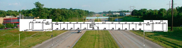
planned I-69 cross section in Bloomington - widening of Route 37
I-69 Construction Rolls On: Summary Judgment Granted in favor of Army Corps and INDOT
US District Judge Larry McKinney granted summary judgment in favor of the Army Corps and INDOT on Tuesday, July 25, 2012.
Opponents of the $3 billion Interstate 69 extension between Indianapolis and Evansville, including Hoosier Environmental Council and Citizens for Appropriate Rural Roads, had argued that the Army Corps of Engineers violated federal law by granting permission to fill wetlands and reroute streams along part of the 142-mile roadway.
The Hoosier Environmental Council and Citizens for Appropriate Rural Roads filed their lawsuit in February 2011. They claimed that the highway would cause "irreparable" environmental harm along a 26-mile section that would cross southern Indiana's Daviess and Greene counties.
The complaint also alleged that the Army Corps violated the Clean Water Act by issuing a permit that would allow INDOT to dump about 215,000 cubic yards of fill material into wetlands and streams to build the highway between Washington and Crane. They maintained that the agency failed to consider other construction approaches that caused would inflict less serious damage to the area's environment, and that the Army Corps did not consider the project's full environmental impact.
Judge McKinney held that the Corps' decision to issue a permit was neither arbitrary nor capricious.
The 65 mile section of the I-69 extension between Evansville and Crane Naval Surface Warfare Center, southwest of Bloomington, is expected to open in the late fall or early winter.
from: Smart Choices, Less Traffic: The 50 Best and Worst Transportation Projects In the United States,
Sierra Club Beyond Oil Campaign, November 2012
http://content.sierraclub.org/beyondoil/content/smart-choices-less-traffic
The I-69 extension connecting Evansville and Indianapolis has been under consideration in Indiana since the 1940s. The price of gas has significantly increased since then, with the price of gas in the 1940s at $0.18 per gallon, but the current road proposal has not reflected the change. Currently estimated at $250 million, the first 90 miles of the proposed 142-mile expansion of Interstate 69 through Southern Indiana has already cost over $1 billion. Based on plans released in recent years, the remaining two phases of the project will likely cost between $800 million and $1.7 billion. The expansion will pave over 4,000 acres of prime farmland and forest. Citizens have raised concerns not only over the loss of land, but also the noise pollution, lack of bicycling and walking access, and transportation dollars going to new roads rather than fixing and maintaining existing infrastructure.
I-69 continuation into Kentucky - several options under study
Outer Beltway planned for north side of Indianapolis plus new sub/urban freeways on south side of Chicago metro area (in Indiana and Illinois)
www.alltolled.com
Indiana's Experience with Tolling and Privatization
Indy Bypass Toll Road - the latest proposal without a need
Illiani Toll Road - will northern Indiana have any free roads left?
New Terrain I-69 - throwing a billion dollars out the window[note: the Indy Bypass would be part of an Outer Beltway for Indianapolis, and the Illiani Toll Road would bypass Gary and other southwest suburbs of Chicago. It looks like it would connect to the future I-355 to complete an Outer Outer Beltway for Chicago.]
www.alltolled.com/indybypass.htm
Indy Bypass Toll Road
www.alltolled.com/illianatollroad.htm
Illiana Toll Road

Illiana Corridor - an Outer Outer Beltway segment for Chicago
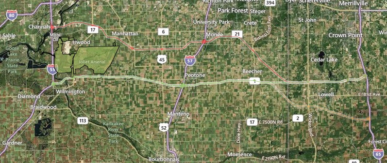
map of three options for Illiana Corridor between I-65 in Indiana to I-55 in Illinois, from Environmental Impact Statement
official site: www.illianacorridor.org
Illiana Corridor would pass near the proposed site for Peotone Airport south of Chicago near I-57. It probably will not be built but if it is the Illiana highway would be a major part of the project. Higher fuel prices and rising airplane ticket costs are leading to consolidation and contraction of the aviation industry.
Chicago O'Hare recently expanded operations into a nearby community, including disinterment of a cemetery.
from: Smart Choices, Less Traffic: The 50 Best and Worst Transportation Projects In the United States,
Sierra Club Beyond Oil Campaign, November 2012
http://content.sierraclub.org/beyondoil/content/smart-choices-less-traffic
The vision for the Illiana Corridor dates back to a 1909 Plan of Chicago that included an outer encircling highway serving northeastern Illinois and northwest Indiana. The Illianna Expressway is a proposed public/private four-lane toll road from Interstate 55 in Illinois to Interstate 65 in Indiana. This project would encourage sprawl development across the rural area, including development of a major "third airport" for the Chicago region in a rural area as well as shifting of freight from rail to truck. The project runs along the southern border of the 20,000-acre Midewin National Tallgrass Prairie. The negative impacts of this project on this natural area are unknown, but additional air and water pollution from the roadway and the sprawl footprint are likely. The official EIS study began in April of 2011 and the project is not currently funded.
Indianapolis
www.aaroads.com/high-priority/corr18.html
The original plan was to extend Interstate 69 from its current terminus to downtown as a six-lane freeway known as Interstate 165, or the Fall Creek Expressway. This route was eliminated due to local opposition and the city and state received interstate substitution funds instead. (The last of the money was just spent in 1996 on a rehabilitation of Madison Avenue).
Ohio River bridges, Louisville, Kentucky suburbs
$2.6 billion for highway expansions and extension of I-265 from Kentucky
built by the Obama administration
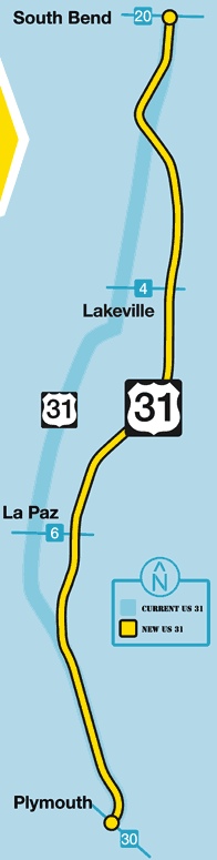
Indiana Route 31 new bypass from South Bend to Plymouth in north central Indiana, under construction
official site: http://us31plysb.com