


Colorado: High Priority Corridors
| Trillion Dollar Highway Plans = Multiple Bypass Surgery a state by state list |
|
| High Priority Corridors specified by Congress in 1991, 1995, 1998, 2005, 2012 |
|
| NAFTA Superhighways | |
| Corridors of the Future | |
| J. Edgar Hoover Parkway: transportation surveillance, mileage taxes, RFID & video tolling |
|
| Paving Appalachia:
Corridor A to X in AL, GA, MD, MS, NC, NY, OH, PA, SC, TN, VA, WV |
|
| Alabama | Nebraska |
| Alaska | Nevada |
| Arizona | New Hampshire |
| Arkansas | New Jersey |
| California | New Mexico |
| Colorado | New York |
| Connecticut | North Carolina |
| Delaware | North Dakota |
| Florida | Ohio |
| Georgia | Oklahoma |
| Hawai'i | Oregon |
| Idaho | Pennsylvania |
| Illinois | Rhode Island |
| Indiana | South Carolina |
| Iowa | South Dakota |
| Kansas | Tennessee |
| Kentucky | Texas |
| Louisiana | Utah |
| Maine | Vermont |
| Maryland | Virginia |
| Massachusetts | Washington |
| Michigan | Washington, D.C. |
| Minnesota | West Virginia |
| Mississippi | Wisconsin |
| Missouri | Wyoming |
| Montana | |
High Priority Corridor 14: Heartland Expressway
I-76, Colorado 71, Nebraska 71, US 26, US 385, SD 79
Heartland Expressway from Denver, Colorado, through Scottsbluff, Nebraska, to Rapid City, South Dakota as follows:
- In the State of Colorado, the Heartland Expressway Corridor shall generally follow-
- Interstate 76 from Denver to Brush; and
- Colorado Highway 71 from Limon to the border between the States of Colorado
- And Nebraska.
- In the State of Nebraska, the Heartland Expressway Corridor shall generally follow-
- Nebraska Highway 71 from the border between the States of Colorado and Nebraska to Scottsbluff;
- United States Route 26 from Scottsbluff to the intersection with State Highway L62A;
- State Highway L62A from the intersection with United States Route 26 to United States Route 385 north of Bridgeport;
- United States Route 385 to the border between the States of Nebraska and South Dakota; and
- United States Highway 26 from Scottsbluff to the border of the States of Nebraska and Wyoming.
- In the State of Wyoming, the Heartland Expressway Corridor shall generally follow United States Highway 26 from the border of the States of Nebraska and Wyoming to the termination at Interstate 25 at Interchange Number 94.
- In the State of South Dakota, the Heartland Expressway Corridor shall generally follow-
- United States Route 385 from the border between the States of Nebraska and South Dakota to the intersection with 1 State Highway 79; and
- State Highway 79 from the intersection with United States Route 385 to Rapid City.''
High Priority Corridor 27: Camino Real Corridor
The Camino Real Corridor from El Paso, Texas, to Denver, Colorado, as follows:
- In the State of Texas, the Camino Real Corridor shall generally follow--
- .arterials from the international ports of entry to I-10 in El Paso County; and
- .I-10 from El Paso County to the New Mexico border.
- In the State of New Mexico, the Camino Real Corridor shall generally follow--
- I-10 from the Texas Border to Las Cruces; and
- I-25 from Las Cruces to the Colorado Border.
- In the State of Colorado, the Camino Real Corridor shall generally follow I-25 from the New Mexico border to Denver continuing to the Wyoming border.
- In the State of Wyoming, the Camino Real Corridor shall generally follow--
- I-25 north to join with I-90 at Buffalo; and
- I-90 to the Montana border.
- In the State of Montana, the Camino Real Corridor shall generally follow--
- I-90 to Billings; and
- Montana Route 3, United States Route 12, United States Route 191, United States Route 87, to I-15 at Great Falls; and
- I-15 from Great Falls to the Canadian border.
High Priority Corridor 48: The Route 50 High Plains Corridor
United States Route 50 corridor from Newton, Kansas (I-135), to Pueblo, Colorado (I-25).
I-70 (Glenwood Canyon) - opposed for many years, ultimately built
I-70 widening in Denver
Jefferson Parkway Denver [470 Beltway missing link through Rocky Flats nuclear waste site]
www.cpr.org/2019/09/03/plutonium-test-results-stall-plan-for-toll-road-near-rocky-flats
Plutonium Test Results Stall Plan For Toll Road Near Rocky Flats
By The Associated Press and Colorado Public Radio Staff
September 3, 2019
Broomfield city officials are suspending their search for investors to help build the Jefferson Parkway after a soil test found elevated levels of plutonium in the highway's planned path.
The toll road would cross a buffer zone on the east side of Rocky Flats, a former nuclear weapons plant northwest of Denver. Broomfield City Council announced it was halting efforts to find a private partner for the project and a city statement said that "the Parkway is not moving forward at this time."
The long-sought road would have eventually completed the 470 beltway around the perimeter of metro Denver.
 Courtesy Jefferson Parkway Public Highway Authority
Plutonium triggers for nuclear warheads were manufactured at the former plant from 1952 to 1989. Later, the manufacturing site underwent a $7 billion cleanup and was turned into a wildlife refuge.
State officials announced in August that a soil test found plutonium levels five times higher than the cleanup standard, but a second test found much lower levels. Officials were seeking more information on the results.
The contentious site remains a flashpoint with activists who have launched several lawsuits to unearth documents on the original investigation and to shut the preserve to human activity. Trails at the national wildlife refuge opened in September 2018.
from: Smart Choices, Less Traffic: The 50 Best and Worst Transportation Projects In the United States
Sierra Club Beyond Oil Campaign, November 2012
http://content.sierraclub.org/beyondoil/content/smart-choices-less-trafficThe Jefferson Parkway is a proposed 4-lane public/private toll road that would build a section of a beltway surrounding Denver. The idea of a federally funded freeway called Interstate 470 around the city of Denver was first proposed in the early 1970s when gas cost $.40/gal. However, the Jefferson Parkway will end several miles from the northern and southern terminals of the Denver beltway, dumping traffic onto local roads in Broomfield, Superior, and Golden causing congestion. The congestion generated on local streets will increase air pollution near residential neighborhoods and schools. Both the city of Golden and town of Superior have sued to prevent the continuation of this project. The Jefferson Parkway will increase oil use and auto-dependence by opening up undeveloped land for sprawling development. Additionally, the proposed route would cut through the eastern edge of the Rocky Flats National Wildlife Refuge, paving a 300 foot wide, 3.5 mile long stretch of Rocky Flats for auto traffic. The Rocky Flats National Wildlife Refuge was created from the former Rocky Flats Nuclear Weapons facility and is closed to the public due to plutonium contamination of its soils. Construction of the Jefferson Parkway will disrupt this contaminated soil, opening the possibility for it to spread to surrounding communities. The 10-mile project is estimated to cost $813 million however; construction is not scheduled to begin until the lawsuit is resolved.
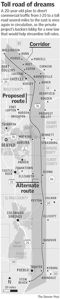
new tollroad paralleling I-25 under consideration
It is curious that road crazy Denver has built a sizeable light rail network and is adding new routes, with more in the planning stages. Former Denver Mayor and Colorado Governor John Hickenlooper was trained as a geologist and spoke at the first ASPO USA conference (Association for the Study of Peak Oil) in Denver in 2005. Light rail is woefully inadequate as a strategy to mitigate Peak Oil but it does suggest privately the transportation agencies have some awareness of the energy situation, even if they don't discuss it in public.